Mgahinga National Park has three of the series of the Volcanoes that form the Virunga Region. These great ranges offer great scenery and opportunities for hiking to traverlers visiting the park. Whether you are a seasoned mountain climber or starter, a hike volcanoes is an experience that you will not forget.
The Virunga is characterized with different vegetation zones that correspond closely to the East African mountains – the afromontane fores below the 2,500m, typical bamboo in areas between 2,500 to 3500m and Afro-alpine moorland in areas above 3500m.
The Virunga gorillas inhabit all the six of the extinct or dormant volcanoes. The Virungas also form the stronghold of the endangered golden monkeys and support relic populations of elephants, buffaloes, yellow backed duiker, and giant forest hog.
The Three Majestic Peaks of Mgahinga
Mgahinga National Park is defined by its three volcanic peaks, each with distinct characteristics and a significant role in the region’s ecological and cultural fabric. These peaks, standing as sentinels at the park’s boundaries, offer both a geographical landmark and a destination for exploration.
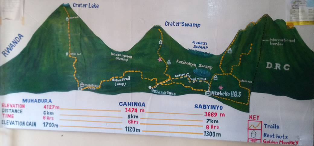
Mount Gahinga (3474m)
Mount Gahinga, the smallest of the three peaks at 3,474 meters, takes its name from the local term for a pile of stones, referencing the volcanic debris that dots its slopes. The mountain’s lower elevations are blanketed by bamboo forests, a habitat critical to the golden monkeys that thrive in the park. Its gentler slopes and rich cultural significance make it a preferred destination for those seeking less demanding hikes. The traditional stone piles that inspired its name symbolise human interaction with this volcanic landscape.
On your way to the park, look out for small piles of stones in the garden fields. The local people call such a pile a ‘Gahinga’.
Mount Gahinga is quite bigger than the average ‘gahinga’ but sitting next to Mount Muhavura does make it look small. A hike, which takes you about, six hours round trip, goes through a good example of a pure Bamboo forest. Gahinga once had a Crater Lake on top but time has changed it into a Lush swamp. Distance to the swamp is 8km.
Mt. Muhavura (4127m) – ‘The Guide’
Seen from all over Kisoro, this volcano acts as a guide. Rising to an elevation of 4,127 meters, Mount Muhabura is the tallest of the three volcanoes in Mgahinga National Park. Its name, derived from the Kinyarwanda word for “guide,” reflects its prominence as a navigational marker visible from great distances. The mountain’s steep slopes are interspersed with montane forests, which gradually transition to Afro-alpine vegetation near the summit. Visitors who ascend its well-marked trails are rewarded with panoramic views of the surrounding landscapes, including the distant peaks of the Rwenzori Mountains and Lake Edward. At the summit lies a crater lake, a serene feature contrasting with the rugged climb.
The typical cone-shaped Mountain provides some of the best views in the country. Much of the climb passes a rocky surface covered by grasses and small shrubs. Once at the top, hikers are rewarded with the view of the Virunga volcanoes, Lake Edward in Queen Elizabeth National Park, Bwindi and the peaks of Rwenzori Mountain. The hike takes approximately 8 hours round trip covering 12km.You are advised to camp at the Muhavura base camp the night before the site has no facilities so you need a tent, water, food and sleeping gear.
Mount Sabyinyo (3366m) – ‘Old man’s teeth’
Like an old man, time has eroded Mt. Sabyinyo’s crown. Mount Sabyinyo, standing at 3,669 meters, is renowned for its rugged, eroded peaks resembling an elder’s worn teeth. This extinct volcano marks the tripoint where the borders of Uganda, Rwanda, and the Democratic Republic of Congo converge, making it a geographical and geopolitical landmark. Its challenging trails attract experienced hikers who navigate steep ridges and sharp ascents. The climb offers a unique opportunity to straddle three countries in a single journey, adding a symbolic layer to the physical adventure.
This volcano offers 3 challenging peaks to climb. A climb up the mountain takes one up a ridge along the eastern side of the climb to peak. If you are to continue, the climb to the peak 11 involves walking a ridge with breath-taking drops into gorges of Rwanda and Uganda, a dual experience you will achieve here.
Finally, the hike up to the peak 111 is steep with several ladders and mush scrambling. You are guaranteed to get your hands dirty en-route to peak111! Once on top, you will be in Rwanda, Democratic Republic of Congo and Uganda, what a triple experience this is!!! The journey takes about eight hours round trip to cover the 14km stretch.